ⵣ · Masterpiece Exhibit · Sahara
The M'Zab Valley
Cities against the sun.
A thousand years ago, a refugee community walked six hundred kilometres into the Algerian Sahara and did the impossible: they built five living cities of stone, palm and light on a plateau that receives less than eighty millimetres of rain a year and every one of them is still inhabited today.
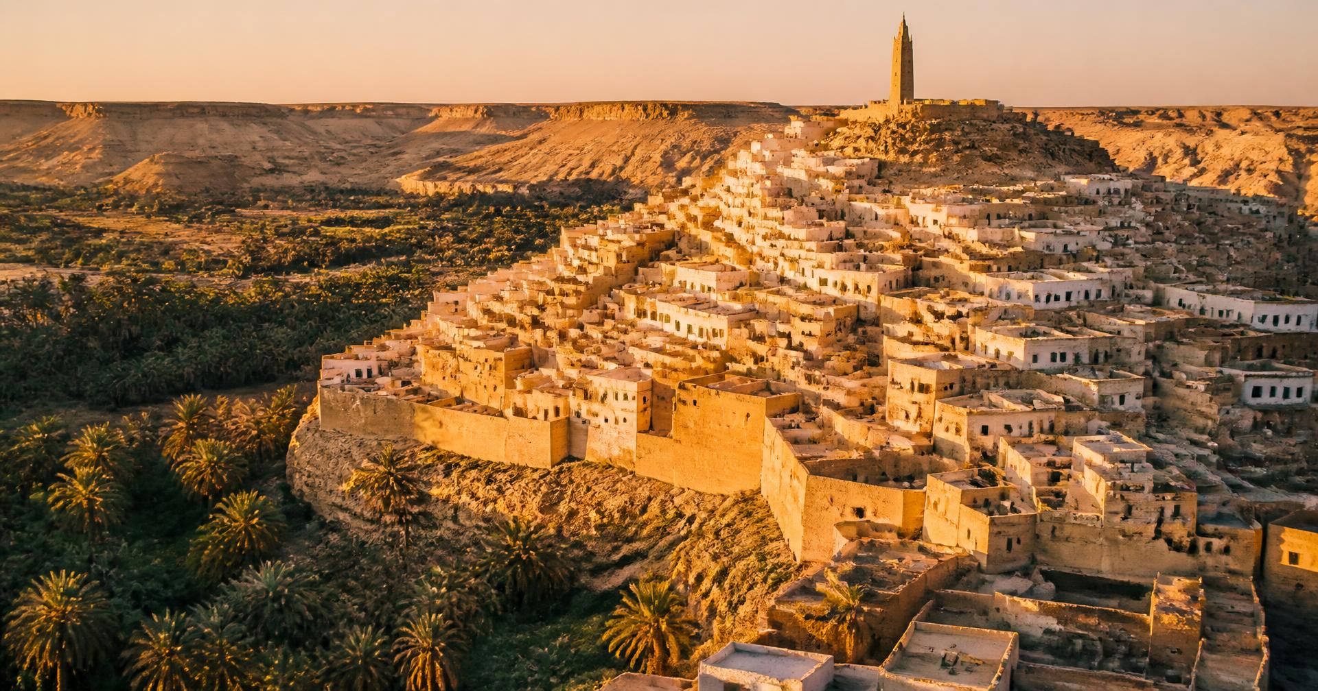
Illustration created for DZ Odyssey. Not a historical photograph.
ⵣ · Where
A valley 600 km south of Algiers
The M'Zab is a shallow, rock-walled valley (wadi) carved into the Chebka plateau of the northern Sahara, in the wilaya of Ghardaïa. It is not on the way to anywhere, that is the point. In the 11th century its remoteness was the safety a persecuted community was looking for. Today it is the reason five ksour survive almost intact where most other pre-modern Saharan towns have vanished.
First ksar founded: El Atteuf, 1012 CE · Bou Noura 1046 · Ghardaïa 1053 (largest, capital of the pentapolis) · Beni Isguen 1347 · Melika 1350. Two later foundations, Berriane and El Guerrara, extended the historical M'Zab into a heptapolis in the 17th and 18th centuries.
Museum data card · M'Zab Valley
- Latitude
- 32°29′ N
- Elevation
- 480 m
- Annual rainfall
- ~ 70 mm
- Summer high
- 45 °C
- Winter low
- −2 °C
- Palms in the groves
- ~ 200,000
Ghardaïa lies on the same latitude as Marrakech and El Paso, but it receives less than a third of their rainfall.
ⵣ · Origins
A civilization born from exile
The story begins not in the desert but in Tahert (present-day Tiaret), 300 km inland from Algiers, where the Rustamid dynasty had ruled a peaceful, scholarly Ibadi imamate from 776 to 909 CE. When the Fatimid armies crushed Tahert, its Ibadi survivors, a Kharijite branch of Islam known for austere piety, strict equality and communal self-government, began a long southward retreat.
They first sheltered at Sedrata, near Ouargla, until Sedrata too was destroyed in the 11th century. Only then did they choose the M'Zab: a valley so unforgiving that no rival power would follow. On 1 Muharram 402 AH (August 1012 CE), the first prayer was said at El Atteuf. The civilization the world now calls Mozabite had begun.
Two forces then converted survival into prosperity. The first was the Trans-Saharan trade: Mozabite caravans linked the Mediterranean to Sub-Saharan Africa, dealing in dates, wool, silver and salt. The second was doctrine: Ibadism demands literacy, thrift, mutual aid and a strict separation between the ummah's spiritual assembly (halqa of the azzaba) and its civic affairs, a discipline that made whole towns behave like disciplined workshops.
ⵣ · The five ksour
A pentapolis, not a city with suburbs
The M'Zab is not a capital and four satellites. It is five autonomous cities that chose, a thousand years ago, to sit within sight of each other's minarets, close enough to share a valley, distant enough to preserve their own councils. Together they form a pentapolis unlike anything else in the Islamic world.
01 · 1012 CE
El Atteuf
The elder, where the first prayer was said.
The founding city of the pentapolis. Its Sidi Brahim mosque (13th c.) is a pure white sculpture of hand-shaped lime, a form so honest that Le Corbusier photographed it and wrote of it as a lesson.
Did you know · Its cemetery is older than most European cathedrals.
02 · 1046 CE
Bou Noura
The luminous one, perched on a rock outcrop.
Built on a natural rock spur, Bou Noura's minaret still functions as an astronomical marker for prayer times, calibrated to the horizon rather than a clock.
Did you know · Its name is thought to preserve a pre-Islamic Berber sun-cult toponym.
03 · 1350 CE
Melika
The queen, highest of the five, watching the valley.
Melika occupies the loftiest ridge and holds the necropolis of Sidi Aïssa, whose white cubic tombs form one of the most photographed landscapes of the Algerian Sahara.
Did you know · The tombs point west, aligned with sunset rather than Mecca, an Ibadi peculiarity.
04 · 1347 CE
Beni Isguen
The sacred, the guardian of Ibadi observance.
Beni Isguen is the strictest of the five: gates still close at sunset, photographs are limited, and every dusk its extraordinary open-air auction (the halqa) is called out one item at a time, a market ritual unchanged since the Middle Ages.
Did you know · Beni Isguen holds one of the oldest continuously used communal libraries in the Muslim world.
05 · 1053 CE
Ghardaïa
The capital, largest, most cosmopolitan of the five.
Ghardaïa's great minaret rises 23 metres above the concentric spiral of the city. Its bright textile souq, the busiest in the Algerian south, still opens and closes to a horn call heard from the summit.
Did you know · It is one of the very few pre-modern Islamic cities where the mosque was designed before the streets.
ⵣ · The wider M'Zab
From pentapolis to heptapolis
The five ksour of the valley are the M'Zab that UNESCO inscribed in 1982. But the historical M'Zab did not stop there. Two later Mozabite foundations, set apart from the wadi itself, extended the community into what Algerian geographers call the heptapolis, the seven cities of the M'Zab.
The UNESCO World Heritage property is precisely the five original ksour, El Atteuf, Bou Noura, Melika, Beni Isguen and Ghardaïa, together with their palm groves and cemeteries. Berriane and El Guerrara are part of the broader historical and cultural M'Zab, but sit outside the inscribed property.
01 · Founded 1690 CE · ~45 km north of Ghardaïa
Berriane
The northern gate of the M'Zab.
Berriane was founded on the northern approach to the valley as Mozabite families spread beyond the original ksour. It shares the same Ibadi institutions, the same white-and-ochre building tradition and the same palm-grove economy, but stands apart from the wadi itself, which is why UNESCO did not include it in the 1982 inscription, even though it is fully part of the M'Zab cultural region.
Did you know · Berriane hosts one of the largest Mozabite communities outside the valley and functions as the M'Zab's northern trading gateway.
02 · Founded 1631 CE · ~110 km north-east of Ghardaïa
El Guerrara
The eastern outpost, closest of the seven to the Sahara's caravan roads.
El Guerrara was founded in the early 17th century on a distinct oasis site well east of the wadi, expanding Mozabite settlement toward the caravan tracks that linked Ouargla and the Ziban. Like Berriane, it belongs to the historical heptapolis but lies outside the UNESCO property, which is confined to the continuous cultural landscape of the five original ksour.
Did you know · El Guerrara's palm grove is fed by a network of foggaras, underground galleries that tap the water table without exposing it to evaporation.
ⵣ · Water & the desert
The world's most elegant flood-control system
The wadi is dry for years, then floods catastrophically. In 1900 the Mozabite community, without engineers, designed a distribution system so equitable it has never had to be revised. When a flood arrives, a stone dam (tabya) slows the water; carved dividing stones (kesria) split the flow into precise fractions; and a network of channels (seguia) feeds the palm grove plot by plot, family by family. Not one drop reaches the desert unused. Modern hydrologists have measured its efficiency at over 90 %.
- The three-level palm grove: date palms on top; fruit trees (pomegranate, apricot) in the middle; vegetables (mint, chilli, tomatoes) at ground level, a stacked microclimate that halves evaporation.
- Communal wells (ain) with counterweight beams (chadouf) still work by hand, the ancestral gesture of the Nile Valley, preserved in the Sahara.
- In 2008 a hundred-year flood destroyed hundreds of modern houses built outside the historical grid, but the old ksour, sitting exactly where the elders had placed them, took no structural damage.
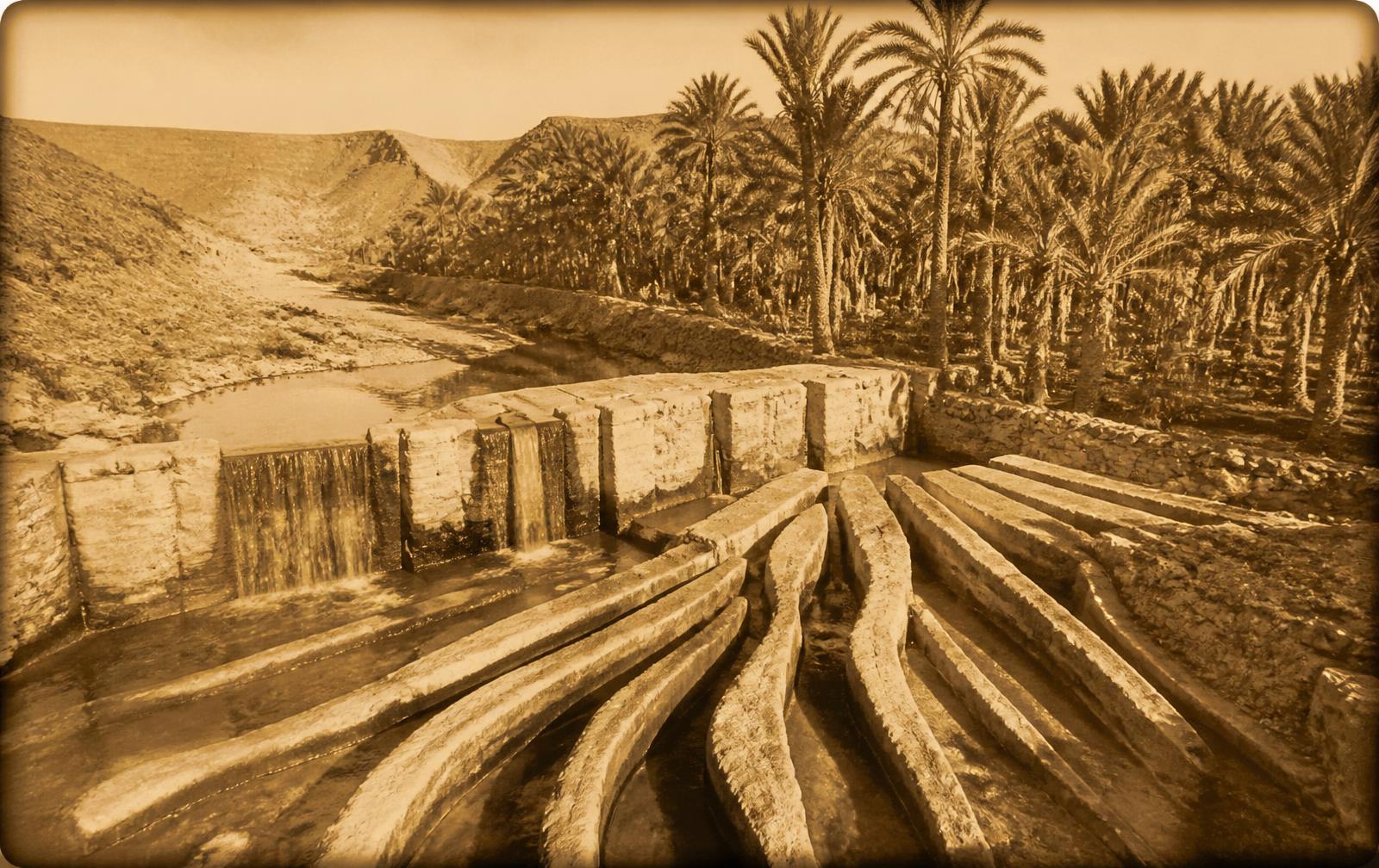
Illustration created for DZ Odyssey. Not a historical photograph.
ⵣ · Architecture
A city as a single organism
There is no formal architect in Ibadi tradition. There is only the community and its rules. The result is a form of urbanism that behaves less like a design and more like a living organism, where every element serves several functions at once, spiritual, climatic, social, defensive.
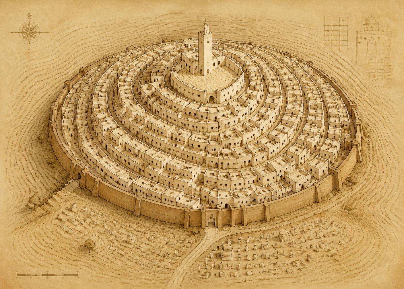
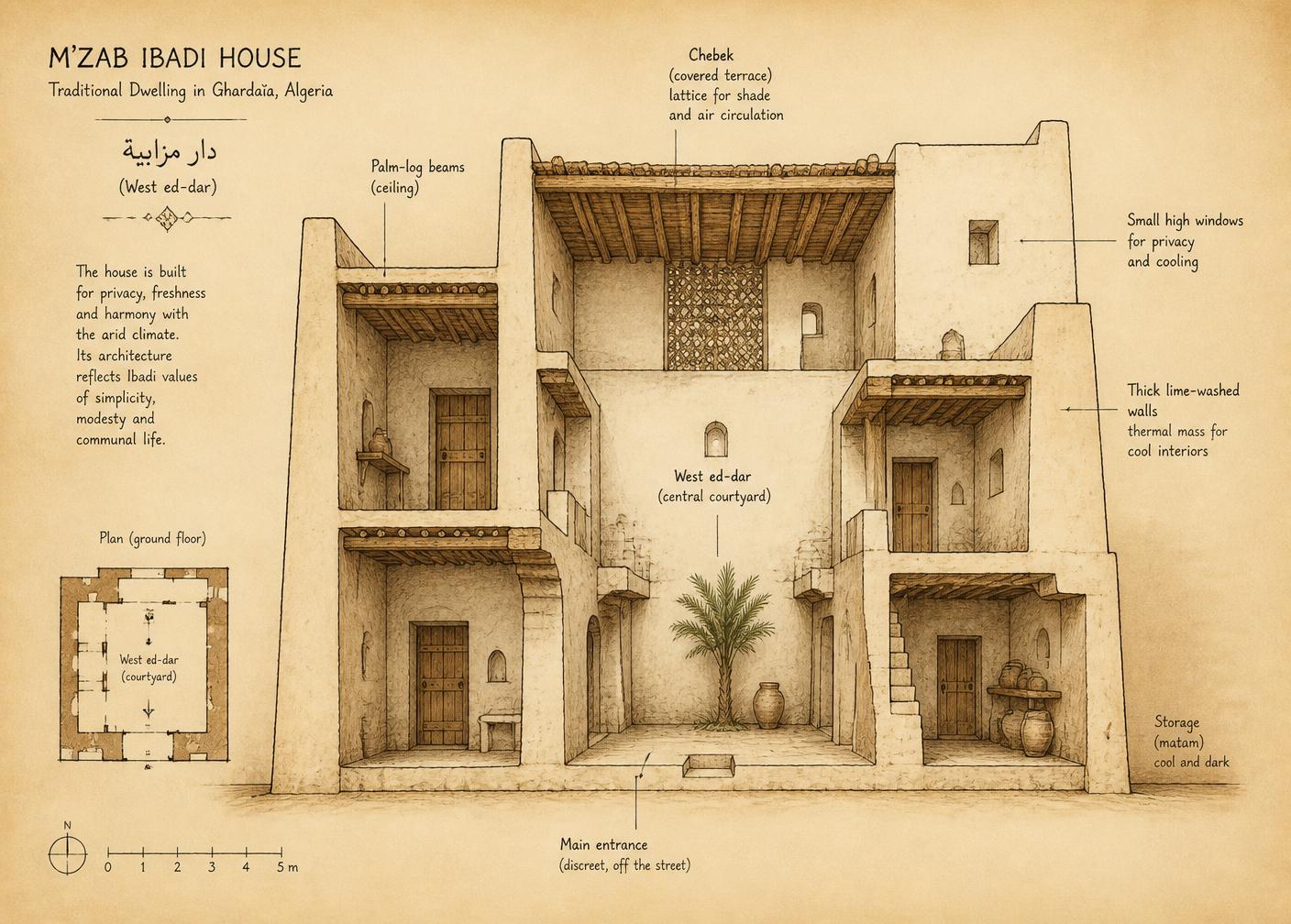
Interpretive reconstruction created for DZ Odyssey. Not a surveyed architectural drawing.
01
The mosque at the summit
Every ksar is crowned by its mosque, never at the centre, always at the highest point. This is not aesthetic: the minaret doubles as a watchtower, a sundial, and, in flood season, a rally point audible across the wadi.
02
The concentric spiral
Streets do not follow a grid; they wind outward from the mosque like a snail shell. A stranger disorients quickly; a resident cannot get lost. The spiral also breaks the wind, forcing sand-laden gusts to lose energy at every turn.
03
Houses folded around a courtyard
The Mozabite house turns its back to the street. Blind whitewashed walls face outward; life happens in the west ed-dar, a central patio open to the sky, cooled at night and shaded by day. Doors are offset so that no visitor can see into the courtyard from the street, a spatial expression of the Ibadi ethic of hidden inner life.
04
Passive cooling before physics knew it had a name
Walls are 40–60 cm thick, lime-washed white on the outside to bounce sunlight, and left rough inside to trap cool air. A lattice roof (chebek) shades the upper terrace while allowing hot air to rise and vent. Interior temperatures stay 10–15 °C below the outside, with no electricity, no fans, no glass.
ⵣ · UNESCO
Why UNESCO listed the M'Zab in 1982
The property inscribed on the World Heritage List in 1982 is the M'Zab pentapolis, the five original ksour of El Atteuf, Bou Noura, Melika, Beni Isguen and Ghardaïa, together with their palm groves and cemeteries. The later Mozabite foundations of Berriane and El Guerrara, described above, belong to the broader historical M'Zab but sit outside this inscription.
Criteria of inscription
The M'Zab exerted a considerable influence on 20th-century architecture and urbanism, from Le Corbusier and Fernand Pouillon to Hassan Fathy and André Ravéreau.
It bears exceptional witness to the culture of a religious minority (Ibadism) that has preserved its cohesion and traditions for a thousand years.
It is an outstanding example of a traditional human settlement adapted to its environment, which has become vulnerable under the impact of irreversible change.
Outstanding Universal Value
Outstanding Universal Value: the M'Zab pentapolis is a complete and functioning example, perhaps the only surviving one, of the medieval Ibadi urban model, in which theology, hydraulics, defence and social order are drawn as one integrated diagram of a city.
Authenticity
Authenticity: houses remain built with local stone, palm-log ceilings and lime plaster. Trades are transmitted father to son. The azzaba assembly still legislates on public space.
Integrity
Integrity: the historic cores of the five ksour, the palm groves and the traditional cemeteries all survive within a single continuous cultural landscape.
Conservation
Since 1988 the Office de Protection et de Promotion de la Vallée du M'Zab (OPVM) has managed the site under a rigorous plan of permanent inhabitants, restricted materials, and monitored restoration, one of the earliest such institutions in the Arab world.
ⵣ · Daily life
A society that runs on assemblies, not authorities
The Mozabite day is governed by two assemblies, both older than any modern institution in Algeria. The halqa of the azzaba, a religious council of a dozen elders, watches over doctrine, education and burial. The djemaâ, a civic assembly of family heads, decides on water, land, disputes and public works. Neither has a president. Neither takes a vote, decisions are debated until a consensus is reached, however long that takes.
Trade is another pillar. The Mozabite retail merchant is a familiar figure in every Algerian city; the community's ancient system of family capital pooling (touiza) still funds shops and marriages across the diaspora. What flows back to the valley is what has kept it standing: money, but also the discipline of a people who left in order to return.
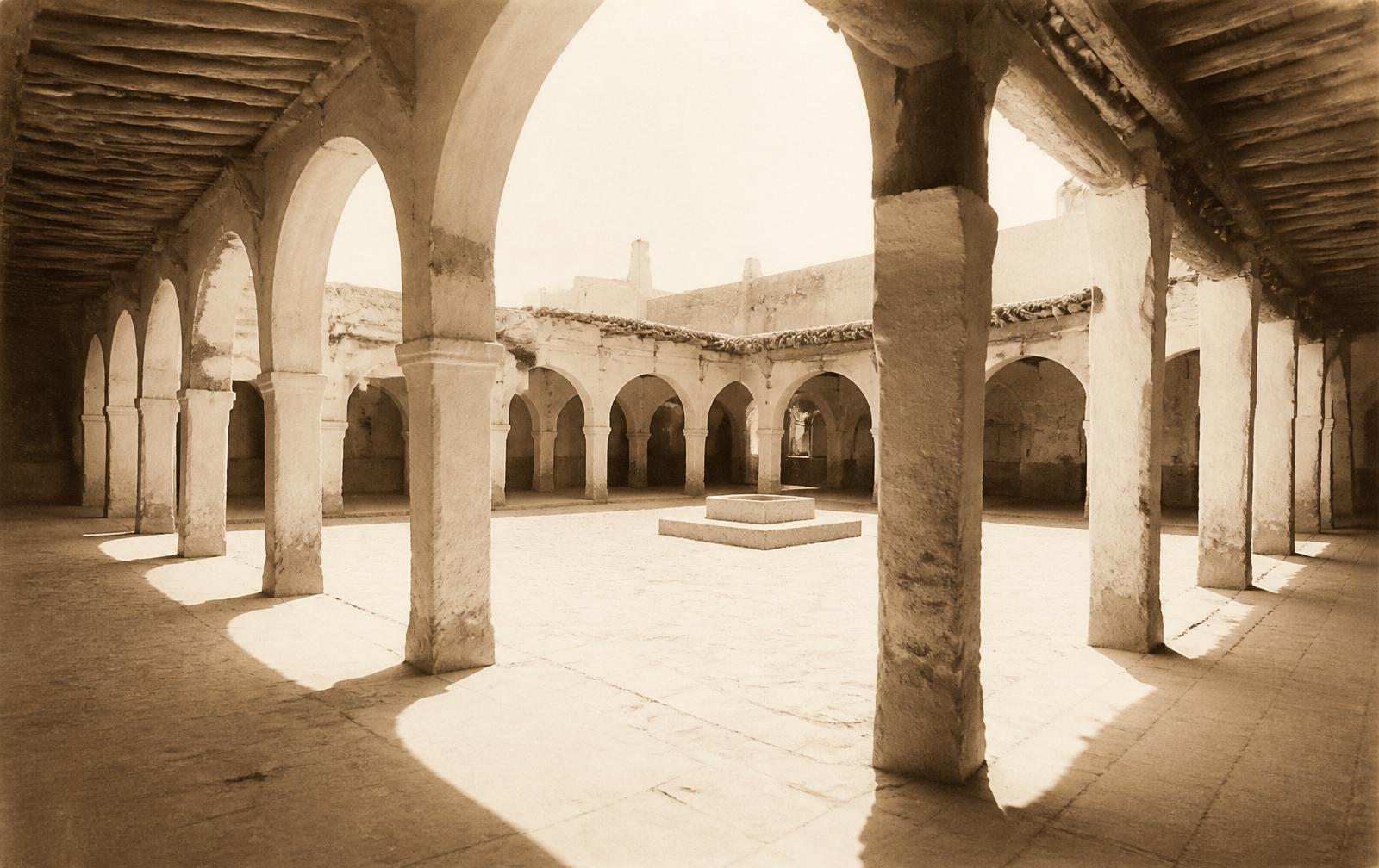
Illustration created for DZ Odyssey. Not a historical photograph.
- The Ghardaïa carpet, geometric, low-pile, dyed in cochineal red and henna gold, is a UNESCO-recognised living craft.
- Silversmithing in Beni Isguen still uses medieval filigree techniques passed on within families.
- The daily market call at Beni Isguen, the halqa, sells everything, from a copper tray to a she-camel, item by item at sunset.
- Hospitality is codified: any traveller who reaches a ksar at dusk is guaranteed shelter, water and a share of the evening meal, not by law, by convention older than law.
ⵣ · Engineering
Why modern architects still study the M'Zab
- Because it is a demonstration, at the scale of a whole society, that thermal comfort, water security and dense living can be achieved with almost no fossil energy.
- Because its urban plan was designed for a climate of extremes, cold nights, brutal days, catastrophic rain, the very conditions many world cities are only now beginning to face under a warming climate.
- Because its construction economy is circular by default: mud plaster returns to earth, palm beams regrow every generation, and the volume of a house is limited by what a family can lift by hand.
- Because it works. A thousand years in, five cities of thirty thousand people together still function under the same rules, in the same walls.
ⵣ · Influence
The lesson that travelled the world
In 1931 Le Corbusier disembarked from a small plane at Ghardaïa. He stayed only a week. He would return to the M'Zab in his notes for the rest of his life, the whitewashed cubic house of El Atteuf appears in his sketchbooks alongside Greek temples and Andean citadels. "An architecture that is not designed," he wrote, "but inherited."
The Egyptian master Hassan Fathy visited a generation later and wrote of the M'Zab as "the finished lesson", the built form of everything he had spent his life arguing for. The French-Algerian architect André Ravéreau moved to Ghardaïa in the 1960s and made the valley his life's study; his book "Le M'Zab, une leçon d'architecture" is still the reference. Fernand Pouillon's whitewashed housing estates in Algiers, still standing today, are unimaginable without it.
Today, from the Aga Khan Award to the New European Bauhaus, from Diébédo Francis Kéré in Burkina Faso to earthen-architecture programmes at MIT and ETH Zürich, the vocabulary of "vernacular sustainability" is unimaginable without the M'Zab. Few places on earth have taught the world so much and asked for so little in return.
"The M'Zab is the built proof that one can be modern without being new."
ⵣ · Did you know?
Six things you were not expecting
In Beni Isguen, the muezzin's call to the last prayer of the day is also the gate-closing signal. No one enters the city after that call until dawn, a rule respected without any physical enforcement since 1347.
The M'Zab lime, burned locally from a soft limestone called timchent, hardens rather than dissolves in floodwater. A wall built in the 12th century can shed a modern flash flood.
There is no monument to a hero in any Mozabite city. The doctrine forbids it. The tallest thing anywhere in the pentapolis is always the minaret.
Mozabite women wear a distinctive white veil (haïk el-mrama) with a single eye opening. It is not concealment; it is a spatial signal, a moving reminder that the streets belong to the community, and the inside of the house to the family.
The valley grows five distinct varieties of date, including the tinicine, so sugar-dense it was once used as caravan currency all the way to Timbuktu.
The 2008 flood killed 33 people. In the historical ksour, which sit above the wadi bed exactly where the founders placed them a thousand years earlier, the death toll was zero.
ⵣ · Museum collection
Photographs, drawings and archival plates
A curated set of illustrations produced for this exhibit, drawn from published UNESCO documentation, André Ravéreau's architectural studies, and the archives of the OPVM. Each plate carries a museum-style caption; full provenance is listed at the end of the exhibit.
Plate 01
Aerial view · Ghardaïa · reconstructed
Contemporary reconstruction based on published UNESCO documentation.
Plate 02
Ksar plan · isometric study
Interpretive reconstruction created for DZ Odyssey after Ravéreau (1981). Not a surveyed architectural drawing.
Plate 03
Ibadi house · sectional drawing
Interpretive reconstruction created for DZ Odyssey after Donnadieu (1986). Not a surveyed architectural drawing.
Plate 04
Kesria · flood-water divider
Archival-style reconstruction, palm grove of Ghardaïa.
Plate 05
Beni Isguen · market arcade
Reference: architectural documentation, OPVM.
Provenance & Sources
Traceable citations, curator notes and further reading.
Verified
Provenance & Sources
Traceable citations, curator notes and further reading.
The exhibit draws on the UNESCO World Heritage record, André Ravéreau's canonical architectural study, and Algerian conservation archives.
Academic References
- RavéreauLe M'Zab, une leçon d'architectureAndré Ravéreau · Sindbad / Actes Sud · 1981The canonical architectural study of the M'Zab, prefaced by Hassan Fathy — the reference work for climatic and communal design of the ksour.
- Habiter le désert : les maisons mozabitesCatherine & Pierre Donnadieu, Hubert Didillon · Mardaga · 1986
- The Ibāḍī Tradition and the Making of the Rustamid ImamateVirginie Prevost · Peeters · 2010
International Organizations
- UNESCOUNESCO · 1982Inscribed 1982 (criteria ii, iii, v) — an intact 10th-century Ibadi urban ensemble that still functions as a living city.
- GettyGetty Conservation Institute
Digital Archives
- Ministry of Culture, AlgeriaThe Algerian public body responsible for the conservation, documentation and interpretation of the M'Zab Valley since 1988.
Further Reading
- Le Corbusier — Œuvre complète (Sahara notebooks & M'Zab studies)Le Corbusier · Éditions Girsberger / Birkhäuser · 1931–1957Le Corbusier travelled to Ghardaïa in 1931 and repeatedly cited the M'Zab as a lesson in rational, humane urbanism.
- CambridgeA History of AlgeriaJames McDougall · Cambridge University Press · 2017